How many clams are there on Equis Beach, and why would you want to know? Tseshaht Fisheries Manager Dave Lightly, Uu-a-thluk staff, and their families worked together from July 12 to 15 to conduct a survey of Tseshaht’s clam tenure on Equis Beach.
The survey will assist the Tseshaht First Nation in creating a management and business plan for their clam beaches. It will also ensure that the clam harvesters are digging in the most productive areas of the beach, and rotating the digging areas to allow the clams to re-populate the beach.
What is a clam survey, you might ask?
It would be impossible to count every single clam on a beach. A clam survey is a systematic way to count the clams in a few small plots, then expand the counts from the plots out to the whole beach to get an estimate of the total number of clams on the beach. But, it’s a little bit harder than just counting clams in a few plots...statistical methods are used to determine how many small plots (called quadrates) should be counted, and where on the beach they ought to be in order to get a reliable estimate of the total number of clams on the beach.
The first step in a clam survey is to use tape measures and a compass to lay out a big grid on the beach at the lowest tide possible. The survey leader then flags the spots where the small plots (quadrates, which are exactly 50 cm by 50 cm squares) will be placed (this was all figured out in the office before getting to the beach).
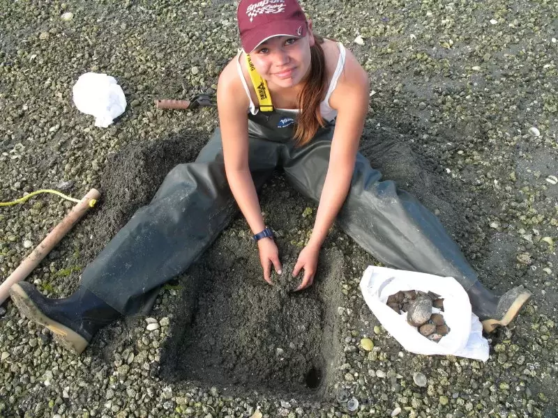
Each quadrate gets dug by a surveyor…but it’s not like regular clam digging! First of all, clam surveyors have to use a small fork on their hands and knees so they can see all of the little clams in their quadrate. Commercial clam digging focuses on the big manila and littleneck clams, but clam surveying means collecting every species and every size of clam possible.
Did you know that most people can only reliably pick out clams that are 20mm or larger?
Clam surveyors also have to be very careful not to go “out of bounds” of their quadrate. They must dig a perfect 50 cm x 50 cm square, to a depth of about 8 inches.
All the clams collected from the quadrate are placed into a bag along with the tag marking the location of the quadrate in the overall grid. The clam sample is then sorted out into different species and into legal and sub-legal sizes, and each portion is counted and weighed. All of the data collected is recorded in a computer spreadsheet, which is used to indicate the most productive areas of the Equis Beach tenure.
The survey data is also used to determine what the total number and total biomass (weight) of clams is for the different species (manila, butter, and littleneck) on the beach. All of this information will be used to improve economic access and help the clam aquaculture business of the Tseshaht Equis Beach Clam Tenure.
Jim Lane, Uu-a-thluk southern region biologist, did a lot of the preliminary work to lay out the grid on the beach ahead of time and worked collaboratively with Tseshaht to design a survey map and to develop a 10-year plan for the beach. Tseshaht staff is working hard to achieve a new management plan and approach for the clam harvest.
“We plan to make Equis Beach as productive as we possibly can. We want to make the beach beneficial to the members of Tseshaht and hopefully to generate revenue,” said Tseshaht Fisheries Manager Dave Lightly. The Equis beach will expose Tseshaht to additional employment opportunities and to the beauty and richness of their Ha-houlthee. It will also allow members to have the opportunity to explore the beach and bring more of their people out to the Broken Group Islands.
Dave enjoyed working with the Uu-a-thluk staff, and says it was a great experience working with such a large and active crowd.
“It was a great opportunity for relationship building,” added Lightly. Everyone worked well together, but Lightly said he especially enjoyed working with Jim Lane.
“All of Uu-a-thluk’s help is greatly appreciated,” said Lightly, adding that “Equis Beach is one of the most interesting beaches. It is very productive and magical.”
